Kashiwazaki-Kariwa Nuclear Power Plant Experience of the Chuetsu-Oki Earthquake not Applied Nuke Info Tokyo No. 144
– The First Post-3/11 Niigata Prefecture Earthquake and Ground Condition Subcommittee –
Introduction
In the 1970s the Japanese government produced “The Earthquake Safety Regulatory Guide: Reviewing the Seismic Design of Nuclear Power Reactor Facilities” for commercial power reactors. In September 2009, this was drastically revised as “The New Guideline.” The task of checking whether nuclear facilities built before that time would be sufficiently safe under “The New Guideline,” nicknamed the “Earthquake Safety Back-check,” has been undertaken by a special committee in the Nuclear and Industrial Safety Agency (NISA) of the Ministry of Economy, Trade and Industry. It is intended that back-checks be carried out for all nuclear facilities in Japan. The back-check for Fukushima Daiichi Nuclear Power Station was completed in 2009 and approved by the Nuclear Safety Commission. “The New Guideline” is supposed to provide a sufficient safety function against a standard seismic movement (Ss) value of 600 gal maximum acceleration in order to “Stop, Cool, and Contain” nuclear facilities.
The following is an exchange of arguments in the central government’s earthquake safety commission two years ago. It is quite clear that discussions in the commission were insufficient.
“(Committee member, Mr. Okamura) Firstly, I’d like to refer to the interplate quake for which you took into consideration the Shioyazaki-Oki Earthquake in the 1930s. I think you know this, but I would like to confirm that this was the site of the Jogan Earthquake, or Jogan tsunami, if you like. It is known, and the results of research have been reported, at least on the tsunami of around 869AD, that it was overwhelmingly greater than the Shioyazakioki Earthquake. I would like to ask you why you did not mention this at all?”
“(Mr. Nishimura, Tokyo Electric Power Company) With regard to the quake in the Jogan era, looking at it from the point of seismic movement, our major concern is that it did not cause much damage. Further, as for the scale, since it was at the same level as an M7.9 quake, we think from the viewpoint of seismic movement evaluation there would be no problem in studying it this way.” (The proceedings of the 32nd for the Seismic and Structural Design Subcommittee, June 24, 2009.)
What did the Jogan Tsunami tell us?
In the URL given below we can see a detailed simulation of the Jogan tsunami presented by the Active Fault and Earthquake Research Center and the Earthquake Research Center of Tokyo University on the basis of their joint research.(unit.aist.go.jp/actfault-eq/seika/h21seika/pdf/namegaya.pdf).
The simulation shows that a vast area of the Ishinomaki and Sendai plain in Miyagi Prefecture and the estuary of the Ukedo River in Fukushima Prefecture were completely inundated by the tsunami. The data in the fault model of the interplate quake amounts to 200 km in length, 100 km in width and 7m slippage. It shows that a 300 km long fault would cause the water level not only of Sendai Bay but also along the coast line of Fukushima to rise.
However, there was no opportunity for the findings concerning the Jogan Earthquake disclosed in January 2010 to be taken into account in the seismic safety evaluation. It is also regrettable that committee member Mr. Yukinobu Okamura (Director of the Active Fault and Earthquake Research Center), who had pointed out Tokyo Electric Power Company’s (TEPCO) deficiencies withdrew his criticisms. Whereas under the guideline of Nuclear Industry and Safety Agency’s fault evaluations for the Late Pleistocene, or between 120,000 and 130,000 years ago, are supposed to be considered, this Jogan Earthquake occurred only about one thousand years ago. TEPCO thus reiterated its arrogant claim of calling the center fault of the Chuetsu-Oki Earthquake “a dead fault.” Committee members such as Mr. Yoshihiro Kinugasa (member of the Committee of Technology and Subcommittee on Earthquake and Ground Condition of Niigata Prefecture), who sided with the group that minimized the fault evaluation, did not even glimpse at the Jogan Earthquake. Moreover, they went so far as to claim that the Futaba fault should be measured as shorter than it actually is.
Did a fault presumed to be immovable move?
“The Earthquake and Ground Condition Subcommittee” was held on August 11, after a break of five months. As the Great East Japan Earthquake had occurred in Japan’s northeast region during the previous meeting there was a very tense atmosphere and the focus was on how the members would view the circumstances after 3/11 and how these would be reflected in the arguments for Kashiwazaki-Kariwa NPP (KK NPP). But TEPCO’s report was disappointing. It aimed to prove that “there was no fact that suggested changes in the previous fault evaluation because GPS monitoring around the nuclear plant site showed that after the Great East Japan Earthquake the distortion tended to work in the direction of relaxing the fold (tension)” and concluded that there was no necessity to change their view that the Madogasaka fault, which extends right into the nuclear plant site, was immovable.
It was clear that TEPCO intended deflect the point of the discussion, since a presumably immovable fault had moved. On April 11, an M7 quake struck close to Iwaki City, in the Hamadori region on the coast of Fukushima Prefecture, causing the Idosawa and Yunotake faults to move and the earthquake fault to appear at the surface of the ground. TEPCO had formerly held that “the Yunotake fault has been inactive since before the Late Pleistocene (about 120,000 to 130,000 years ago)” on the grounds that the outcrop study revealed no displacement variation or deformation in the stratum distribution that covered the fault.” It did move, however, and the quake fault appeared at the surface of the ground. According to an analysis by the Earthquake Research Center of Tokyo University, a characteristic “tensile stress condition” was formed on the hanging wall of the fault by the extremely large-scale tectonic deformation of the M9 quake. If this is true, then the safety evaluation would have to be reviewed. This evaluation claimed that the (Madogasaka) fault “would not move” because the boring survey proved that the volcanic ash deposit of the Yasuda stratum (more than 130,000 years old) was deposited horizontally, crossing over the Madogasaka syncline.
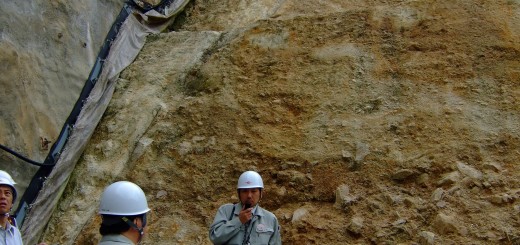
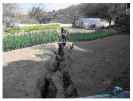 |
| The deep crack in the ground surface running southeast beyond the road. (From the National Institution of Advanced Industrial Science and Technology website) |
Formation of fault and fold
According to the earthquake safety evaluation, if the fault belt that connects the South Sadoshima fault, the F-D fold group and the Takada-Oki fault group were destroyed in one movement, the whole length of the zone would be 70 km to 100 km. These are reverse faults that tilt east and extend directly beneath KK NPP. The degree of displacement is quite a bit larger than the F-B fault which defines the standard quake movement. With this in mind, Mr. Tateishi (member of the Committee of Technology and Subcommittee on Earthquake and Ground Condition of Niigata Prefecture), pointed out, “I think we need an evaluation for a linked fault movement up to the Takada-Oki fault. Then we need to discuss and find out why the fault that we had evaluated as immovable did actually move. Looking only at the result (of the Great East Japan Earthquake) will not help us get to the point.” Admitting that the present evaluation is ‘peripheral,’ Mr. Hijikata, head of TEPCO’s Architecture and Earthquake-Resistance (Anti-Seismic) Technology Center, stated that he would like to explain the matter in the report produced on the basis of NISA’s instruction.”
What was of interest was that he explained the fault activity that would occur in the nuclear plant site if the Madogasaka fault became active with reference to a model experiment by the Central Research Institute of Electric Power Industry on the morphological development of overlapping strata faults and folds that would occur in association with reverse fault displacement.
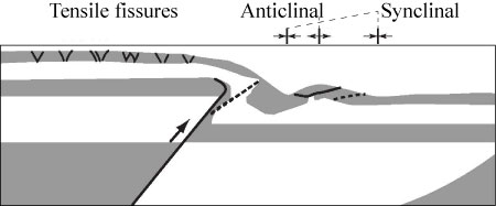 |
| A study on the development process of a reverse fault-active fold belt by model experiment. (Source: Central Research Institute of Electric Power Industry report) |
In the figure above, the reverse fault corresponds to the Madogasaka fault and the tensile fissures correspond to the fault underneath the nuclear plant site. The reactors and the turbine buildings at KK NPP stand right over this fault. A thoroughgoing review of what would happen if the fault underneath the plant site moved is necessary.
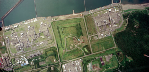
Needless to say, KK NPP stands right on top of the concentrated distortion zone on the eastern margin of the Sea of Japan. Although it is yet to be accepted as established theory, this zone is the borderline region between the Eurasian Plate and the North American Plate. It can be seen that the subduction is still shallow and a sea trench is not yet formed. Both the Chuetsu Earthquake (2004) and Chuetsu-Oki Earthquake (2007) were caused by the strain of compressive forces directed towards the earth’s crust from the Sado bank on one side and the Echigo mountain range on the other.
It so happened that thirteen hours after the Great East Japan Earthquake, an M6.7 quake occurred at the border of Niigata and Nagano Prefectures. A movement of the Tokamachi west margin fault belt, that seismologists had long been afraid of, inflicted severe damage on the surrounding area, only 40 km to 60 km south of the KK nuclear power plant. Tectonic deformation, as ever, is still ongoing.
Sadao Kaneko (The Niigata Prefecture People’s Association to Protect the Homeland and Life)