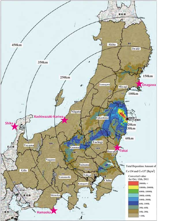
A map displaying the status of radioactive contamination on Japanese soil has been published. MEXT’s investigative results came from large, highly sensitive radiation detectors installed on a helicopter that surveyed gamma rays over a wide area. The gamma ray measurements were converted into soil contamination data, and the Cesium-137 and Cesium-134 totals are displayed on the map.
As understood from the map, topsoil contamination from cesium is not simply confined to Fukushima Prefecture, but rather extends as a belt across an extensive zone. Within the zone that has now been shown to exist, there is contamination more than 250 km southwest of the Fukushima Daiichi Nuclear Power Station. Furthermore, the contamination does not extend continuously, but sporadically, with occurrences of highly contaminated areas in separated locations. Kashiwa City, Chiba Prefecture, located on the east side of the Tokyo Metropolis, has hot spots with high concentrations of radioactive contamination. Kashiwa is a large city of 400,000 people, but one of the garbage incinerators there has had to halt operations because it could not securely store additional incinerated ash due to a buildup of large amounts of cesium exceeding the national standards.
Because the prefectures of Tochigi and Ibaraki border Fukushima Prefecture, at the time of the accident there was great concern over radioactive contamination. For three months, the citizens in those prefectures showed a great deal of interest in radioactivity. At the same time, as Gunma does not border Fukushima Prefecture, there was not the same concern. Since the contamination results have been announced, however, CNIC has received continuous consultations from citizens and farmers in Gunma Prefecture.
Nobuko Tanimura(CNIC)

Return to CNIC's Earthquakes and Nuclear Power page
Return to NIT 145contents

